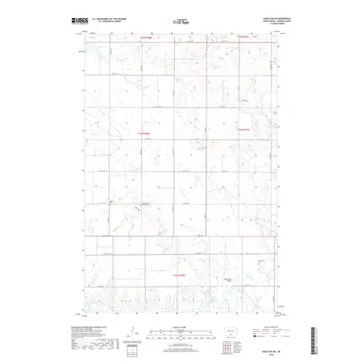
2018 Map of Hazelton SW
USGS Topo · Published 2018About this map
Horsehead Valley defines the southern portion of this landscape in Emmons County, where the terrain breaks toward the drainage of Beaver Creek. The map reveals a strictly organized section-line road grid, including 77th St SW and 79th St SW, which serves a dispersed agricultural community. This area is punctuated by small, significant historical sites that offer critical clues for genealogical research. Three distinct burial grounds are documented here: Baptist Cem and Saint Johns Lutheran Cem are located near one another in the central portion of the survey, while Winchester Cem is situated further east above the valley. These sites, along with the paths of Sand Creek and the larger Beaver Creek, illustrate the enduring relationship between the early settler community and the natural topography of the North Dakota plains.
Find a feature on this map
26 named features on this map. Tap any name to fly to it.
Don’t see what you’re looking for? This feature index may not catch every label — zoom into the map to look around manually.
Map Details
Editions of this 2018 Hazelton SW Map
This is the sole edition of this map. No revisions or reprints were ever made.
Other maps of this area

1954 · Bismarck
USGS Topo · 1:250,000

1958 · Bismarck
USGS Topo · 1:250,000

1968 · Cannon Ball
USGS Topo · 1:24,000

1968 · Cannon Ball SE
USGS Topo · 1:24,000

1968 · Fort Yates NE
USGS Topo · 1:24,000

1971 · Grassna NW
USGS Topo · 1:24,000

1971 · Hazelton
USGS Topo · 1:24,000

1971 · Hazelton SW
USGS Topo · 1:24,000

1971 · Grassna NE
USGS Topo · 1:24,000
1971 · Hazelton NW
USGS Topo · 1:24,000