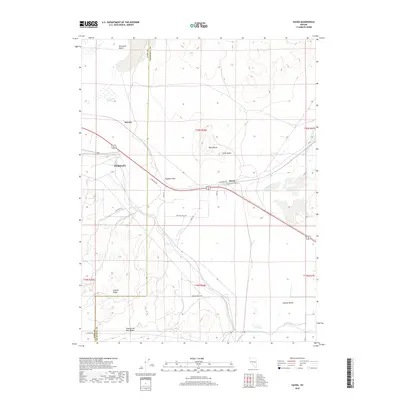
2018 Map of Hazen
USGS Topo · Published 2018About this map
Hazen and the surrounding high-desert terrain of the Fortymile Desert define this portion of the Lyon and Churchill County line. The landscape is characterized by its transition from the peaks of the Virginia Range to the wide expanse of the Twenty-Six Mile Desert. Local water management is visible through the engineering of the KX Lateral Canal and the Hazen Drain, which serve the agricultural efforts at Swingle Bench. The map captures the intersection of natural landmarks like Ragtown Pass and Patua Hot Springs with modern infrastructure, including the Gas Line Rd and Farm District Rd. Smaller points of interest such as Darwin, Black Butte, and Little Butte offer specific anchor points for local history research in this arid region of western Nevada.
Find a feature on this map
28 named features on this map. Tap any name to fly to it.
Don’t see what you’re looking for? This feature index may not catch every label — zoom into the map to look around manually.
Map Details
Editions of this 2018 Hazen Map
This is the sole edition of this map. No revisions or reprints were ever made.
Other maps of this area

1890 · Wadsworth
USGS Topo · 1:125,000

1891 · Wabuska
USGS Topo · 1:125,000

1892 · Wadsworth
USGS Topo · 1:125,000

1894 · Wadsworth
USGS Topo · 1:125,000

1894 · Wabuska
USGS Topo · 1:125,000

1908 · Carson Sink
USGS Topo · 1:250,000

1910 · Carson Sink
USGS Topo · 1:250,000

1951 · Soda Lake
USGS Topo · 1:62,500

1951 · Fallon
USGS Topo · 1:62,500

1957 · Two Tips
USGS Topo · 1:62,500