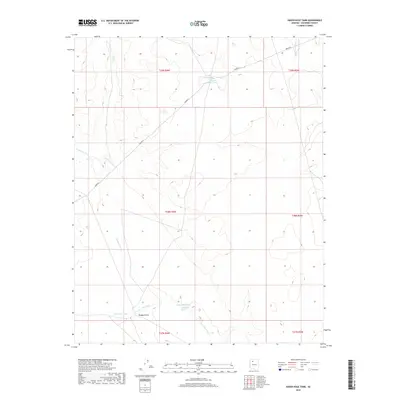
2018 Map of Hazen Hole Tank
USGS Topo · Published 2018About this map
The arid high country of northern Coconino County is defined here by a network of drainage features and essential water management sites. In this 2018 survey, the landscape is oriented around Hazen Hole Tank and the neighboring Number Eleven Tank, critical catchments in a region where water security is the primary human footprint. An extensive Aqueduct line traverses the northern sections, cutting across the natural flow of drainages like Black Tank Wash and Sand Cr. The lower portion of the map is dominated by the broad paths of Sandstone Wash and Farm Dam Draw, which feed into the Farm Dam Tank near Rodgers Draw. These features demonstrate the ongoing reliance on managed water storage for ranching or land use in the Arizona desert, highlighting the intersection of natural topography and infrastructure.
Find a feature on this map
15 named features on this map. Tap any name to fly to it.
Don’t see what you’re looking for? This feature index may not catch every label — zoom into the map to look around manually.
Map Details
Editions of this 2018 Hazen Hole Tank Map
This is the sole edition of this map. No revisions or reprints were ever made.
Other maps of this area

1886 · Chino
USGS Topo · 1:250,000

1891 · Chino
USGS Topo · 1:250,000

1948 · Williams
USGS Topo · 1:250,000

1954 · Williams
USGS Topo · 1:250,000

1956 · Williams
USGS Topo · 1:250,000

1960 · Williams
USGS Topo · 1:250,000

1961 · Williams
USGS Topo · 1:250,000

1980 · Hazen Hole Tank
USGS Topo · 1:24,000
1980 · Tin House
USGS Topo · 1:24,000
1980 · Black Tank
USGS Topo · 1:24,000