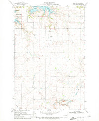
1969 Map of Hazen NW
USGS Topo · Published 1971About this map
Lake Sakakawea dominates the northern reaches of this Mercer County landscape, where the rising waters of the mid-century reservoir formed Expansion Bay and Beulah Bay. This 1969 survey, overseen by Governor William L. Guy and the State of North Dakota Water Commission, captures a rural prairie topography transitioning into the Hille State Game Management Area. The map is particularly notable for its density of family and community burial sites scattered across the uplands, including Bethel Cem, Link Cem, and St Martin Cem. To the south, the winding course of Antelope Creek cuts through the terrain, while small industrial footprints like a Gravel Pit appear near the southern section lines, reflecting the local land use during this period of state water management and agricultural stability.
Find a feature on this map
13 named features on this map. Tap any name to fly to it.
Don’t see what you’re looking for? This feature index may not catch every label — zoom into the map to look around manually.
Map Details
Editions of this 1969 Hazen NW Map
This is the sole edition of this map. No revisions or reprints were ever made.
Other maps of this area

1954 · McClusky
USGS Topo · 1:250,000

1958 · McClusky
USGS Topo · 1:250,000

1967 · Emmet SE
USGS Topo · 1:24,000

1967 · Blackwater Lake SE
USGS Topo · 1:24,000

1967 · Emmet SW
USGS Topo · 1:24,000

1968 · Beulah
USGS Topo · 1:24,000

1968 · Hazen West
USGS Topo · 1:24,000

1968 · Hazen East
USGS Topo · 1:24,000

1969 · Hazen NE
USGS Topo · 1:24,000

1969 · Beulah NE
USGS Topo · 1:24,000