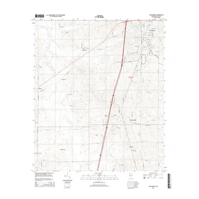
2015 Map of Hazlehurst
USGS Topo · Published 2015About this map
Hazlehurst serves as the regional hub for this portion of Copiah County, where the historic street grid meets established landmarks like the Hazlehurst Cem and Lake Hazle. To the west and south, the terrain is defined by the drainage basins of Bayou Pierre and its many tributaries, including Mill Cr and Jones Cr. This landscape is marked by a network of rural settlements and family-linked burial grounds that speak to generations of local residency. Smaller communities such as Gallatin, Glancy, and Martinsville anchor the surrounding countryside, connected by historic routes like Old Natchez Rd and Old Port Gibson Rd. Genealogists will find particular value in the numerous documented cemeteries, including Antioch Cem, Starling Cem, and Wade Cem, which are situated near established homesteads and country crossroads.
Find a feature on this map
89 named features on this map. Tap any name to fly to it.
Don’t see what you’re looking for? This feature index may not catch every label — zoom into the map to look around manually.
Map Details
Editions of this 2015 Hazlehurst Map
This is the sole edition of this map. No revisions or reprints were ever made.
Other maps of this area

1953 · Natchez
USGS Topo · 1:250,000

1956 · Natchez
USGS Topo · 1:250,000

1959 · Natchez
USGS Topo · 1:250,000

1963 · Dentville
USGS Topo · 1:24,000
1963 · Crystal Springs
USGS Topo · 1:24,000

1963 · Smyrna
USGS Topo · 1:24,000
1963 · Gallman
USGS Topo · 1:24,000

1963 · Hazlehurst
USGS Topo · 1:24,000

1963 · Shady Grove
USGS Topo · 1:24,000

1972 · Midway
USGS Topo · 1:24,000