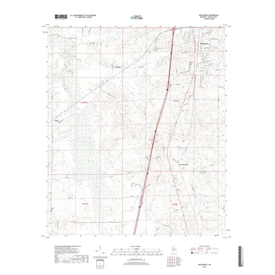
2018 Map of Hazlehurst
USGS Topo · Published 2018About this map
Hazlehurst serves as the primary hub of this Copiah County landscape, where the street grid fans out into the surrounding piney woods and agricultural lands of central Mississippi. To the west, the settlement of Gallatin sits near the headwaters of Johnson Cr, while Martinsville and Glancy mark the smaller community nodes that define the local geography. The area is heavily intersected by creek systems including Bayou Pierre, Mill Cr, and King Cr, which carve through the terrain and influence the placement of historic routes like the Old Natchez Rd and Old Port Gibson Rd. Genealogists will find a wealth of specific data points across the sheet, with several family and community burial grounds documented, such as Wade Cem, Spring Hill Cem, and Tyson Cem. From the waters of Lake Hazle to the winding course of Bahala Cr, the map illustrates a landscape where modern infrastructure meets deeply rooted rural tradition.
Find a feature on this map
96 named features on this map. Tap any name to fly to it.
Don’t see what you’re looking for? This feature index may not catch every label — zoom into the map to look around manually.
Map Details
Editions of this 2018 Hazlehurst Map
This is the sole edition of this map. No revisions or reprints were ever made.
Other maps of this area

1953 · Natchez
USGS Topo · 1:250,000

1956 · Natchez
USGS Topo · 1:250,000

1959 · Natchez
USGS Topo · 1:250,000

1963 · Dentville
USGS Topo · 1:24,000
1963 · Crystal Springs
USGS Topo · 1:24,000

1963 · Smyrna
USGS Topo · 1:24,000
1963 · Gallman
USGS Topo · 1:24,000

1963 · Hazlehurst
USGS Topo · 1:24,000

1963 · Shady Grove
USGS Topo · 1:24,000

1972 · Midway
USGS Topo · 1:24,000