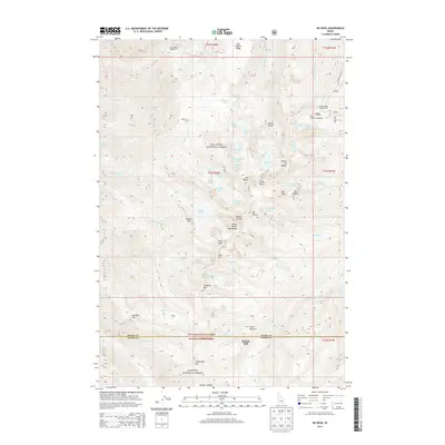
2013 Map of He Devil
USGS Topo · Published 2013About this map
The Seven Devils Mountains dominate this high-altitude landscape on the border of Idaho and Adams counties. This 2013 survey details the complex topography surrounding the legendary peaks of He Devil and She Devil, where the Nez Perce National Forest meets the Payette National Forest. The map documents a classic mountain-economy and recreational landscape, including remote landmarks like Hibbs Cow Camp and the site of Rankin Mill. A dense concentration of alpine waters, such as Mirror Lake, Basin Lake, and the Hanson Lakes, are pocketed among jagged ridges like Dry Diggins Ridge and Devils Throne. Transportation and access points are preserved through labels for the Windy Saddle Campground and the winding course of the Squaw Creek Rd, providing a clear record of the area's wilderness infrastructure in the early 21st century.
Find a feature on this map
75 named features on this map. Tap any name to fly to it.
Don’t see what you’re looking for? This feature index may not catch every label — zoom into the map to look around manually.
Map Details
Editions of this 2013 He Devil Map
This is the sole edition of this map. No revisions or reprints were ever made.
Other maps of this area

1920 · Seven Devils Mining District
USGS Topo · 1:48,000

1922 · He Devil
USGS Topo · 1:48,000

1938 · Riggins
USGS Topo · 1:96,000

1945 · Riggins
USGS Topo · 1:125,000

1955 · Grangeville
USGS Topo · 1:250,000

1957 · He Devil
USGS Topo · 1:62,500

1957 · Cuprum
USGS Topo · 1:62,500

1959 · Grangeville
USGS Topo · 1:250,000
1963 · Pollock Mountain
USGS Topo · 1:24,000
1964 · Kessler Creek
USGS Topo · 1:24,000