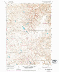
1951 Map of Head Of Butch Creek
USGS Topo · Published 1994About this map
The Rosebud Indian Reservation in Mellette County defines this landscape, mapped during the mid-century as part of the Missouri River Basin development program. The terrain is characterized by the high plateaus of Prospect and Running Bird, where numerous small stock ponds and reservoirs dot the drainages. Butch Creek flows through the northern reaches, while the south is marked by the broad Cottonwood Valley. The tiny settlement of Cottonwood sits at the southern edge of the quadrangle near the banks of Cottonwood Creek. Local ranching life is anchored by landmarks like the UP Ranch, providing a window into the rural economy of this South Dakota interior before the expansion of modern infrastructure. Photorevisions from the 1970s reveal the persistence of these isolated ranching outposts and water management features in a region defined by its wide open ranges and Red Fish heights.
Find a feature on this map
9 named features on this map. Tap any name to fly to it.
Don’t see what you’re looking for? This feature index may not catch every label — zoom into the map to look around manually.
Map Details
Editions of this 1951 Head Of Butch Creek Map
3 editions found
Other maps of this area

1951 · Stamford SE
USGS Topo · 1:24,000

1951 · Cedar Butte NE
USGS Topo · 1:24,000

1951 · Okaton SW
USGS Topo · 1:24,000

1951 · Murdo 3 NW
USGS Topo · 1:24,000

1951 · Murdo 3 NE
USGS Topo · 1:24,000

1951 · Okaton SE
USGS Topo · 1:24,000

1955 · Martin
USGS Topo · 1:250,000

1958 · Martin
USGS Topo · 1:250,000

1980 · Kadoka
USGS Topo · 1:100,000

1981 · Cedar Butte
USGS Topo · 1:25,000