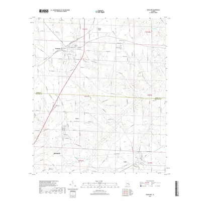
2018 Map of Headland
USGS Topo · Published 2018About this map
The city of Headland and the smaller communities of Kinsey and Webb define this area of the Wiregrass region in the late 2010s. The landscape is marked by a mix of residential growth and aeronautical utility at the Headland Municipal Airport. Several local cemeteries, including Piney Grove Cem, Bethlehem Cem, and Gardens of Memory Cem, provide significant landmarks for genealogists tracking family roots in Houston and Henry Counties. The terrain is drained by numerous small watercourses such as Little Omusee Cr, Beulah Cr, and Burdeshaw Mill Cr, which cut through the agricultural and developing suburban lands. While modern infrastructure like E Main St and Houston Co 105 facilitates travel toward Dothan, the survival of older church and cemetery sites like Gates of Heaven Cem maintains a link to the area's established community history.
Find a feature on this map
143 named features on this map. Tap any name to fly to it.
Don’t see what you’re looking for? This feature index may not catch every label — zoom into the map to look around manually.
Map Details
Editions of this 2018 Headland Map
This is the sole edition of this map. No revisions or reprints were ever made.
Other maps of this area

1953 · Dothan
USGS Topo · 1:250,000

1954 · Dothan
USGS Topo · 1:250,000

1955 · Dothan
USGS Topo · 1:250,000

1969 · Dothan East
USGS Topo · 1:24,000
1969 · Dothan West
USGS Topo · 1:24,000
1969 · Midland City
USGS Topo · 1:24,000

1969 · Headland
USGS Topo · 1:24,000
1969 · Echo
USGS Topo · 1:24,000

1969 · Newville
USGS Topo · 1:24,000

1970 · Haleburg
USGS Topo · 1:24,000