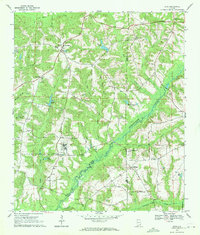
1969 Map of Echo
USGS Topo · Published 1971About this map
Echo sits atop the high ground of the Wiregrass region in this late-1960s survey, serving as a central hub for a landscape defined by its creek systems and rural congregational life. The terrain is deeply etched by the Choctawhatchee River and its numerous tributaries, including PORK Creek, West Turkey Creek, and Riley Creek. This map documents a high density of rural institutions, from the Jr High School at Echo to scattered churches like Mt Sinai Ch and Old Center Ch that anchored these farming communities.
Find a feature on this map
45 named features on this map. Tap any name to fly to it.
Don’t see what you’re looking for? This feature index may not catch every label — zoom into the map to look around manually.
Map Details
Editions of this 1969 Echo Map
2 editions found
Other maps of this area

1942 · Enterprise
USGS Topo · 1:125,000

1948 · Ozark
USGS Topo · 1:62,500

1950 · Ozark
USGS Topo · 1:62,500

1953 · Dothan
USGS Topo · 1:250,000

1954 · Dothan
USGS Topo · 1:250,000

1955 · Dothan
USGS Topo · 1:250,000

1960 · Ewell
USGS Topo · 1:24,000

1960 · Pinckard
USGS Topo · 1:24,000
1962 · Pinckard
USGS Topo · 1:25,000
1962 · Ewell
USGS Topo · 1:25,000