
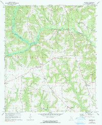
1970 Map of Haleburg
USGS Topo · Published 1972About this map
Haleburg and the rural communities of eastern Henry County are defined by a network of dendritic stream systems including Abbie Creek and Foster Creek. This 1970 survey shows a landscape dominated by agricultural patterns, where small hamlets like Balkum and Tumbleton serve as local anchors. Family and community life is centered around numerous country houses of worship, such as Union Ch, Adoniram Ch, and Mt Pleasant Ch, many of which are situated alongside small burial grounds like the Balkum Cem and Culpepper Cem. The placement of these landmarks along ridges above the winding branches of Peterman Creek and Sandy Creek illustrates the historic settlement patterns of the Wiregrass region. Notable infrastructure includes a Gaging Sta on Abbie Creek and a Radio Tower near Browns Crossroads, reflecting the mix of traditional rural life and mid-century technical utility.
Find a feature on this map
34 named features on this map. Tap any name to fly to it.
Don’t see what you’re looking for? This feature index may not catch every label — zoom into the map to look around manually.
Map Details
Editions of this 1970 Haleburg Map
2 editions found
Other maps of this area

1953 · Dothan
USGS Topo · 1:250,000

1954 · Dothan
USGS Topo · 1:250,000

1955 · Dothan
USGS Topo · 1:250,000

1969 · Abbeville West
USGS Topo · 1:24,000

1969 · Fort Gaines
USGS Topo · 1:24,000

1969 · Headland
USGS Topo · 1:24,000

1969 · Abbeville East
USGS Topo · 1:24,000

1969 · Newville
USGS Topo · 1:24,000

1970 · Columbia NE
USGS Topo · 1:24,000

1970 · Sigma
USGS Topo · 1:24,000