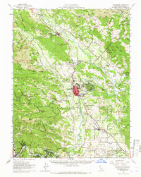
1955 Map of Healdsburg
USGS Topo · Published 1966About this map
The Russian River defines the central corridor of this Sonoma County survey, winding through the Alexander Valley and passing the expanding street grid of Healdsburg. This era shows a landscape transitioning between established agricultural roots and modern infrastructure, evidenced by the proximity of the Sonoma County Airport to traditional landmarks like the Shiloh Cemetery and the Alexander Valley Sch. The Northwestern Pacific railroad tracks parallel the river, connecting riverside communities such as Geyserville, Lytton, and Windsor. To the west, the topography rises sharply toward Mt Jackson and the Armstrong Redwoods State Park, while the eastern landscape is marked by the complex drainage of Maacama Creek and Mark West Creek. This record documents the mid-century layout of small settlements like Rio Nido and Hacienda alongside local industries like the Mericoma Mine and several sawmills.
Find a feature on this map
148 named features on this map. Tap any name to fly to it.
Don’t see what you’re looking for? This feature index may not catch every label — zoom into the map to look around manually.
Map Details
Editions of this 1955 Healdsburg Map
2 editions found
Other maps of this area

1916 · Santa Rosa
USGS Topo · 1:62,500

1920 · Healdsburg
USGS Topo · 1:62,500

1921 · Skaggs
USGS Topo · 1:62,500

1921 · Kelseyville
USGS Topo · 1:62,500

1927 · Calistoga
USGS Topo · 1:62,500

1933 · Healdsburg
USGS Topo · 1:48,000

1935 · Sebastopol
USGS Topo · 1:48,000

1938 · Hopland
USGS Topo · 1:62,500

1940 · Healdsburg
USGS Topo · 1:62,500

1942 · Sebastopol
USGS Topo · 1:62,500