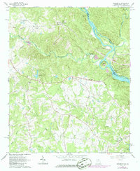
1964 Map of Heardmont
USGS Topo · Published 1966About this map
Heardmont and its surrounding rural landscape in Elbert County occupy a terrain defined by the winding Savannah River and its numerous tributaries. This survey captures a specific era of infrastructure development, most notably the construction of a large reservoir system indicated by the presence of Clarks Hill Lake and the significant river feature at Trotters Shoals. The transition of the landscape is further emphasized by roads marked as under construction and the path of the Seaboard railroad through the community of Pearl. Scattered through the hills are numerous legacy landmarks essential for genealogical research, including Hunters Chapel, Bethlehem Ch, and Banks Sch. Small family and community spaces like Gods Acre Cem and Bethel Grove Cem are documented alongside established rural centers like Beverly, providing a detailed look at the social and geographic layout of the Georgia-South Carolina borderlands prior to widespread modern development.
Find a feature on this map
37 named features on this map. Tap any name to fly to it.
Don’t see what you’re looking for? This feature index may not catch every label — zoom into the map to look around manually.
Map Details
Editions of this 1964 Heardmont Map
Other maps of this area

1893 · Elberton
USGS Topo · 1:125,000

1906 · Crawfordville
USGS Topo · 1:125,000

1953 · Athens
USGS Topo · 1:250,000

1954 · Greenville
USGS Topo · 1:250,000

1955 · Broad
USGS Topo · 1:24,000

1955 · Chennault
USGS Topo · 1:24,000

1958 · Greenville
USGS Topo · 1:250,000

1958 · Athens
USGS Topo · 1:250,000

1958 · Elberton
USGS Topo · 1:62,500

1959 · Athens
USGS Topo · 1:250,000