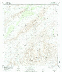
1983 Map of Heart Mountain
USGS Topo · Published 1984About this map
Heart Mountain and the Tinaja Mountains dominate this Brewster County landscape, defining a high-desert environment where water sources are the primary markers of human presence. The map reveals an extensive network of wind-powered infrastructure essential for ranching in the Big Bend region, with named sites such as Becket Corner Windmill, Arrott Windmill, and Yokey Windmill scattered across the terrain. These landmarks, alongside a solitary Landing Strip, represent the remote ranching operations active during the mid-1970s and early 1980s.
Find a feature on this map
29 named features on this map. Tap any name to fly to it.
Don’t see what you’re looking for? This feature index may not catch every label — zoom into the map to look around manually.
Map Details
Editions of this 1983 Heart Mountain Map
2 editions found
Other maps of this area

1917 · Santiago Peak
USGS Topo · 1:62,500

1917 · Hood Spring
USGS Topo · 1:62,500

1918 · Bone Spring
USGS Topo · 1:125,000

1918 · Hood Spring
USGS Topo · 1:62,500

1918 · Santiago Peak
USGS Topo · 1:62,500

1920 · Monument Spring
USGS Topo · 1:62,500

1920 · Marathon
USGS Topo · 1:62,500

1921 · Monument Spring
USGS Topo · 1:62,500

1921 · Marathon
USGS Topo · 1:62,500

1931 · Hood Spring
USGS Topo · 1:62,500