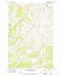
1970 Map of Heath
USGS Topo · Published 1973About this map
The small settlement of Heath serves as the focal point for this 1970 Fergus County survey, situated at the confluence of several vital watercourses. The landscape is defined by the drainage patterns of Big Spring Creek and the intricate networks of Marcott Creek and East Fork Big Spring Creek. The presence of the Mountain View Sch and a Community Hall indicates a established rural community, while the Landing Strip and various Gravel Pit sites suggest localized industry and transportation infrastructure. Genealogists and researchers can trace family lands near named features like Hansen Creek or the Shammel terrain. The map captures a moment in Montana's ranching and agricultural history where the balance between small-town infrastructure and the natural topography of canyons and forks remained clearly visible on the land.
Find a feature on this map
17 named features on this map. Tap any name to fly to it.
Don’t see what you’re looking for? This feature index may not catch every label — zoom into the map to look around manually.
Map Details
Editions of this 1970 Heath Map
This is the sole edition of this map. No revisions or reprints were ever made.
Other maps of this area

1889 · Big Snowy Mountain
USGS Topo · 1:250,000

1893 · Big Snowy Mountain
USGS Topo · 1:250,000

1941 · Lewistown
USGS Topo · 1:62,500

1941 · Judith Peak
USGS Topo · 1:62,500

1944 · Lewistown
USGS Topo · 1:62,500

1944 · Judith Peak
USGS Topo · 1:62,500

1954 · Roundup
USGS Topo · 1:250,000

1954 · Lewistown
USGS Topo · 1:250,000

1958 · Roundup
USGS Topo · 1:250,000

1959 · Lewistown
USGS Topo · 1:250,000