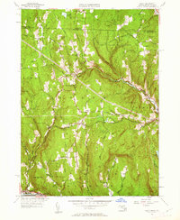
1961 Map of Heath
USGS Topo · Published 1962About this map
The Colrain State Forest dominates the northeastern uplands of this 1961 survey, where the rugged topography of the Berkshire foothills is defined by family-named landmarks like Christian Hill and Phillips Hill. The landscape reflects a deeply established rural network of the mid-20th century, centered on the village of Heath and the smaller settlements of North Heath, Adamsville, and Dell. For local historians and genealogists, the map provides a precise record of historical burial grounds, including Center Cem, South Cem, and the remote Cutting Cem near the Vermont border. Along the southern edge, the terrain drops sharply toward the Deerfield River and the route of the Mohawk Trail. An intriguing industrial relic, the Davis Mine, sits tucked away in the western hills of Rowe, while the intricate network of brooks like Avery Brook and West Branch North River highlights the complex drainage patterns of this high-elevation township.
Find a feature on this map
57 named features on this map. Tap any name to fly to it.
Don’t see what you’re looking for? This feature index may not catch every label — zoom into the map to look around manually.
Map Details
Editions of this 1961 Heath Map
2 editions found
Other maps of this area

1886 · Hawley
USGS Topo · 1:62,500

1889 · Wilmington
USGS Topo · 1:62,500

1890 · Hawley
USGS Topo · 1:62,500

1890 · Greenfield
USGS Topo · 1:62,500

1891 · Wilmington
USGS Topo · 1:62,500

1891 · Brattleboro
USGS Topo · 1:62,500

1893 · Brattleboro
USGS Topo · 1:62,500

1894 · Greenfield
USGS Topo · 1:62,500

1894 · Hawley
USGS Topo · 1:62,500

1899 · Wilmington
USGS Topo · 1:62,500