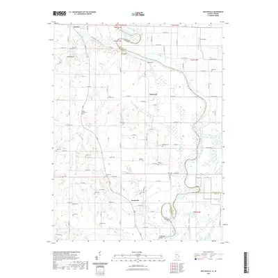
2021 Map of Heathsville
USGS Topo · Published 2021About this map
The Wabash River carves a serpentine boundary between Crawford County, Illinois, and Sullivan County, Indiana, defining the geography of this riverine landscape. On the Illinois side, the settlement of Heathsville and the crossroads of Richwoods sit amidst a high concentration of family and community burial grounds, such as Fuller Cem, Maddox Cem, and Baker Cem. This density of cemeteries, alongside the prominent Indian Mound near Palestine, points to a long history of human occupation along the river bluffs. The terrain is marked by distinctive elevations like Bristol Hill and Shawn Hill, which overlook the wetlands and oxbows of the floodplain. Notable water features include Buzzard Pond, Long Pond, and the Horseshoe Cutoff, illustrating the river's shifting course over time. In the northeast, Mann Airport provides a modern contrast to the agricultural and natural features that dominate the quadrangle.
Find a feature on this map
85 named features on this map. Tap any name to fly to it.
Don’t see what you’re looking for? This feature index may not catch every label — zoom into the map to look around manually.
Map Details
Editions of this 2021 Heathsville Map
This is the sole edition of this map. No revisions or reprints were ever made.
Other maps of this area

1917 · Birds
USGS Topo · 1:62,500

1942 · Birds
USGS Topo · 1:62,500

1943 · Merom
USGS Topo · 1:24,000

1943 · Carlisle
USGS Topo · 1:24,000

1943 · Oaktown
USGS Topo · 1:24,000

1943 · Sullivan
USGS Topo · 1:24,000

1953 · Indianapolis
USGS Topo · 1:250,000

1956 · Indianapolis
USGS Topo · 1:250,000
1956 · Sullivan
USGS Topo · 1:24,000

1956 · Vincennes
USGS Topo · 1:250,000