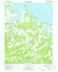
1968 Map of Heathsville
USGS Topo · Published 1971About this map
Heathsville serves as the inland hub for this portion of the Northern Neck, where the topography transition from tidal inlets to agricultural uplands. The landscape is defined by its deep relationship with the water, as the Potomac River meets the intricate creek systems of Coan River and Great Wicomico River. Dozens of smaller waterways like Presley Creek and Hull Creek carve the land into named necks and points, including Neuman Neck and Quarter Neck.
Find a feature on this map
78 named features on this map. Tap any name to fly to it.
Don’t see what you’re looking for? This feature index may not catch every label — zoom into the map to look around manually.
Map Details
Editions of this 1968 Heathsville Map
3 editions found
Other maps of this area

1892 · Piney Point
USGS Topo · 1:62,500

1894 · Piney Point
USGS Topo · 1:62,500

1894 · Point Lookout
USGS Topo · 1:62,500

1895 · Nomini
USGS Topo · 1:125,000

1895 · Piney Point
USGS Topo · 1:62,500

1898 · Nomini
USGS Topo · 1:125,000

1898 · St. Marys
USGS Topo · 1:125,000

1901 · Piney Point
USGS Topo · 1:62,500

1906 · St. Marys
USGS Topo · 1:125,000

1912 · Point Lookout
USGS Topo · 1:62,500