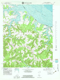
1968 Map of Heathsville
USGS Topo · Published 1983About this map
Heathsville serves as the focal point of this coastal Virginia landscape, where the inland terrain is deeply incised by the Coan River and its various tributaries. The social fabric of the late 1960s is evidenced by numerous community crossroads like Sissons Corner, Middletons Corner, and Luttrels Corner, alongside landmarks such as St Stephens Ch and Northumberland High Sch. The map reveals a legacy of water-powered industry and drainage management, featuring multiple millponds such as Clark Millpond, Sydnors Millpond, and Downings Millpond.
Find a feature on this map
75 named features on this map. Tap any name to fly to it.
Don’t see what you’re looking for? This feature index may not catch every label — zoom into the map to look around manually.
Map Details
Editions of this 1968 Heathsville Map
3 editions found
Other maps of this area

1892 · Piney Point
USGS Topo · 1:62,500

1894 · Piney Point
USGS Topo · 1:62,500

1894 · Point Lookout
USGS Topo · 1:62,500

1895 · Nomini
USGS Topo · 1:125,000

1895 · Piney Point
USGS Topo · 1:62,500

1898 · Nomini
USGS Topo · 1:125,000

1898 · St. Marys
USGS Topo · 1:125,000

1901 · Piney Point
USGS Topo · 1:62,500

1906 · St. Marys
USGS Topo · 1:125,000

1912 · Point Lookout
USGS Topo · 1:62,500