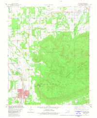
1981 Map of Heavener
USGS Topo · Published 1981About this map
Runestone State Park overlooks the valley from the slopes of Poteau Mountain, marking a landscape where high ridgelines and industrial activity meet. The town of Heavener serves as a central hub, defined by the extensive operations of the Kansas City Southern railroad and its associated Strip Mine and mine sites to the south. This 1981 survey details a community rich in genealogical markers, from the large Oakdale Cem near the town center to more isolated burial grounds like Burns Cem and Springhill Cem. To the north, the smaller settlement of Monroe is situated along Sugarloaf Creek, while the Muni Airport and several churches, including Springhill Ch and Community Ch, dot the lowlands between the hills. The terrain is shaped by the complex drainage of the Poteau River and its numerous tributaries, including Horsepen Creek and Morris Creek.
Find a feature on this map
36 named features on this map. Tap any name to fly to it.
Don’t see what you’re looking for? This feature index may not catch every label — zoom into the map to look around manually.
Map Details
Editions of this 1981 Heavener Map
This is the sole edition of this map. No revisions or reprints were ever made.
Other maps of this area

1887 · Poteau Mountain #2
USGS Topo · 1:62,500

1887 · Greenwood
USGS Topo · 1:62,500

1890 · Fort Smith
USGS Topo · 1:125,000

1890 · Poteau Mountain
USGS Topo · 1:125,000

1899 · Poteau Mountain
USGS Topo · 1:125,000

1900 · Sallisaw
USGS Topo · 1:125,000

1900 · Winding Stair
USGS Topo · 1:125,000

1909 · Winding Stair
USGS Topo · 1:125,000

1911 · Sallisaw
USGS Topo · 1:125,000

1943 · Fort Smith
USGS Topo · 1:125,000