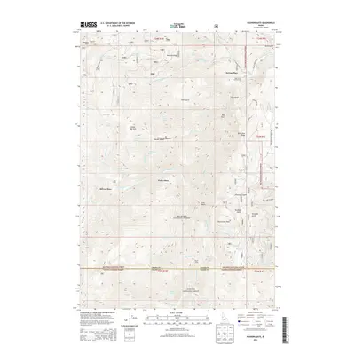
2013 Map of Heavens Gate
USGS Topo · Published 2013About this map
Heavens Gate serves as a prominent vantage point overlooking the complex drainage systems of the Nez Perce National Forest and Payette National Forest. This high-altitude landscape is characterized by a network of steep canyons and ridges, where the Rapid River and its numerous tributaries like Shingle Cr and Cottonwood Cr have carved deep into the terrain. The presence of several named sites such as DeVeny Place, Potter Place, and McCrea Place indicates a history of seasonal habitation or land use in these remote reaches, while the Rapid River Fish Hatchery denotes modern resource management within the river system. Transportation through the area is largely defined by forest access routes such as White Bird Ridge Rd and specialized sites like Vista Point Lookout, which provide structural evidence of fire monitoring and recreational infrastructure in the Idaho backcountry during the early 21st century.
Find a feature on this map
67 named features on this map. Tap any name to fly to it.
Don’t see what you’re looking for? This feature index may not catch every label — zoom into the map to look around manually.
Map Details
Editions of this 2013 Heavens Gate Map
This is the sole edition of this map. No revisions or reprints were ever made.
Other maps of this area

1920 · Seven Devils Mining District
USGS Topo · 1:48,000

1922 · He Devil
USGS Topo · 1:48,000

1938 · Riggins
USGS Topo · 1:96,000

1945 · Riggins
USGS Topo · 1:125,000

1955 · Grangeville
USGS Topo · 1:250,000

1957 · He Devil
USGS Topo · 1:62,500

1957 · Cuprum
USGS Topo · 1:62,500

1959 · Grangeville
USGS Topo · 1:250,000

1963 · Indian Mountain
USGS Topo · 1:24,000
1963 · Pollock Mountain
USGS Topo · 1:24,000