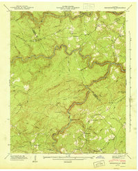
1945 Map of Hebbertsburg
USGS Topo · Published 1945About this map
Hebbertsburg sits at the intersection of rural life and rugged topography along the boundary of Morgan and Cumberland counties in the mid-1940s. The landscape is defined by the deep winding cuts of the Obed River and Daddy Creek, which separate high features like Little Peavine Mountain and Pilot Mountain. This era captures a network of water-crossings essential for travel before modern infrastructure, including Holland Ford, Potter Ford, and the Waltman Ford Bridge. Local centers of community life are visible through scattered schoolhouses and churches, such as Potter Chapel Sch and New Home Ch, while the Pilot Knob Lookout Tower stands as a sentinel over the heavily wooded ridges. The presence of the Hebbertsburg Post Office and small clusters at Frankfort and Hallway illustrate the dispersed nature of these upland Tennessee settlements.
Find a feature on this map
51 named features on this map. Tap any name to fly to it.
Don’t see what you’re looking for? This feature index may not catch every label — zoom into the map to look around manually.
Map Details
Editions of this 1945 Hebbertsburg Map
This is the sole edition of this map. No revisions or reprints were ever made.
Other maps of this area

1887 · Kingston
USGS Topo · 1:125,000

1891 · Kingston
USGS Topo · 1:125,000

1893 · Kingston
USGS Topo · 1:125,000

1895 · Wartburg
USGS Topo · 1:125,000

1896 · Wartburg
USGS Topo · 1:125,000

1935 · Lancing
USGS Topo · 1:24,000

1935 · Pilot Mountain
USGS Topo · 1:24,000

1936 · Hebbertsburg
USGS Topo · 1:24,000

1936 · Fox Creek
USGS Topo · 1:24,000

1936 · Twin Bridges
USGS Topo · 1:24,000