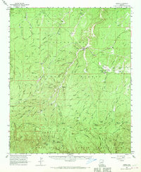
1961 Map of Heber
USGS Topo · Published 1970About this map
Heber and Overgaard serve as the primary hubs in this high-country landscape, where the Sitgreaves National Forest dominates the terrain. The 1961 survey captures a period of established forest management and early aviation, evidenced by the Heber Ranger Station and the Overgaard Airport. Ranching and water access are central to the settlement pattern, with family names attached to landmarks like Worick Ranch, Walnut Ranch, and Gibson Ranch. The complex drainage system of the Mogollon Rim is meticulously documented through features such as Wildcat Canyon, Brookbank Draw, and Carrizo Creek. To the south, the Apache Indian Reservation begins, marked by Wildhorse Lake Campground and West Blue Lake Campground. These details reflect a mid-century economy built on timber, livestock, and the growing importance of mountain recreation.
Find a feature on this map
101 named features on this map. Tap any name to fly to it.
Don’t see what you’re looking for? This feature index may not catch every label — zoom into the map to look around manually.
Map Details
Editions of this 1961 Heber Map
3 editions found
Other maps of this area

1886 · Holbrook
USGS Topo · 1:250,000

1893 · Holbrook
USGS Topo · 1:250,000

1954 · Holbrook
USGS Topo · 1:250,000

1957 · Holbrook
USGS Topo · 1:250,000

1958 · Holbrook
USGS Topo · 1:250,000

1960 · Holbrook
USGS Topo · 1:250,000

1961 · Woods Canyon
USGS Topo · 1:62,500

1961 · Clay Springs
USGS Topo · 1:62,500

1961 · Heber
USGS Topo · 1:62,500

1961 · Cibecue
USGS Topo · 1:62,500