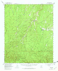
1961 Map of Heber
USGS Topo · Published 1982About this map
Heber and Overgaard serve as the primary hubs of activity in this 1961 survey of Navajo County, positioned at the intersection of Highway 260 and State Highway 277. The landscape is dominated by the high-altitude forests of the Sitgreaves National Forest, punctuated by established homesteads and cattle operations such as the Wyrick Ranch, Walnut Ranch, and Gibson Ranch. A Cem is located south of Heber, providing a focal point for genealogical research in this timber and ranching community.
Find a feature on this map
109 named features on this map. Tap any name to fly to it.
Don’t see what you’re looking for? This feature index may not catch every label — zoom into the map to look around manually.
Map Details
Editions of this 1961 Heber Map
3 editions found
Other maps of this area

1886 · Holbrook
USGS Topo · 1:250,000

1893 · Holbrook
USGS Topo · 1:250,000

1954 · Holbrook
USGS Topo · 1:250,000

1957 · Holbrook
USGS Topo · 1:250,000

1958 · Holbrook
USGS Topo · 1:250,000

1960 · Holbrook
USGS Topo · 1:250,000

1961 · Woods Canyon
USGS Topo · 1:62,500

1961 · Clay Springs
USGS Topo · 1:62,500

1961 · Heber
USGS Topo · 1:62,500

1961 · Cibecue
USGS Topo · 1:62,500