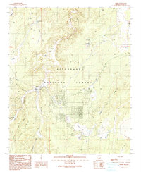
1990 Map of Heber
USGS Topo · Published 1991About this map
The neighboring settlements of Heber and Overgaard dominate the central portion of this 1990 survey, appearing as established residential hubs within the Sitgreaves National Forest. The map captures the infrastructure of these mountain communities, showing a grid of streets, a Trailer Park, and essential services like the Heber Ranger Station and a local Cem. The landscape is deeply incised by drainages such as Black Canyon and Buckskin Canyon, while flatter regions like Oklahoma Flat host specialized developments, including the Overgaard Airport and a Golf Course. Local recreation and utility are evidenced by Tall Timbers County Park and various water sources like Bigler Tank and Hewitt Tank, which were vital for sustaining life and ranching in this high-country environment. The inclusion of a Heliport and several radio towers suggests the area's role as a regional coordination point for forest management and emergency services.
Find a feature on this map
47 named features on this map. Tap any name to fly to it.
Don’t see what you’re looking for? This feature index may not catch every label — zoom into the map to look around manually.
Map Details
Editions of this 1990 Heber Map
This is the sole edition of this map. No revisions or reprints were ever made.
Other maps of this area

1886 · Holbrook
USGS Topo · 1:250,000

1893 · Holbrook
USGS Topo · 1:250,000

1954 · Holbrook
USGS Topo · 1:250,000

1957 · Holbrook
USGS Topo · 1:250,000

1958 · Holbrook
USGS Topo · 1:250,000

1960 · Holbrook
USGS Topo · 1:250,000

1961 · Clay Springs
USGS Topo · 1:62,500

1961 · Heber
USGS Topo · 1:62,500

1970 · Red Knoll
USGS Topo · 1:24,000
1971 · Zeniff
USGS Topo · 1:24,000