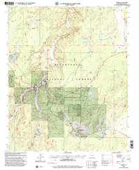
1998 Map of Heber
USGS Topo · Published 2000About this map
Sitgreaves National Forest surrounds the high-altitude communities of Heber and Overgaard, which are mapped here at a time of significant residential expansion in the late 1990s. The landscape is defined by the canyon systems of Black Canyon and Brookbank Canyon, while the human footprint is concentrated along the intersection of highway 260 and 277. The infrastructure of the era is remarkably detailed, showing the Heber Ranger Station, the Black Mesa Administrative Area, and the Overgaard Airport. Genealogy and local history researchers will find the Tall Timbers Cemetery and various outlying properties such as Crandell Ranch and Apple Ranch. The map captures the transition from ranching and forest service operations to more modern amenities like the local Golf Course, Athletic Field, and numerous mobile home parks that began to populate Oklahoma Flat.
Find a feature on this map
66 named features on this map. Tap any name to fly to it.
Don’t see what you’re looking for? This feature index may not catch every label — zoom into the map to look around manually.
Map Details
Editions of this 1998 Heber Map
This is the sole edition of this map. No revisions or reprints were ever made.
Other maps of this area

1886 · Holbrook
USGS Topo · 1:250,000

1893 · Holbrook
USGS Topo · 1:250,000

1954 · Holbrook
USGS Topo · 1:250,000

1957 · Holbrook
USGS Topo · 1:250,000

1958 · Holbrook
USGS Topo · 1:250,000

1960 · Holbrook
USGS Topo · 1:250,000

1961 · Clay Springs
USGS Topo · 1:62,500

1961 · Heber
USGS Topo · 1:62,500

1970 · Red Knoll
USGS Topo · 1:24,000
1971 · Zeniff
USGS Topo · 1:24,000