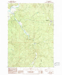
1985 Map of Hebo
USGS Topo · Published 1985About this map
The Nestucca River winds through the heart of the Siuslaw National Forest in this mid-1980s provisional study, a landscape dominated by the timber and conservation interests of Tillamook County. The settlement of Hebo serves as a central hub, flanked by the Hebo Work Camp and a local hatchery, reflecting the area's reliance on both forest management and river resources. Notable elevation changes are marked by Gauldy Ridge and Mount Hebo, where a substation and various peaks overlook a dense network of drainages including Three Rivers and Cedar Creek.
Find a feature on this map
42 named features on this map. Tap any name to fly to it.
Don’t see what you’re looking for? This feature index may not catch every label — zoom into the map to look around manually.
Map Details
Editions of this 1985 Hebo Map
This is the sole edition of this map. No revisions or reprints were ever made.
Other maps of this area

1941 · Nestucca Bay
USGS Topo · 1:62,500

1942 · Ginger Peak
USGS Topo · 1:62,500

1942 · Spirit Mtn
USGS Topo · 1:62,500

1942 · Nestucca Bay
USGS Topo · 1:62,500

1942 · Tillamook
USGS Topo · 1:62,500

1948 · Vancouver
USGS Topo · 1:250,000

1950 · Vancouver
USGS Topo · 1:250,000

1950 · Vancouver
USGS Topo · 1:250,000

1955 · Hebo
USGS Topo · 1:62,500

1955 · Blaine
USGS Topo · 1:62,500