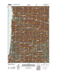
2011 Map of Heceta Head
USGS Topo · Published 2011About this map
Heceta Head stands as a prominent coastal landmark on this Oregon shoreline, overlooking a landscape where the Pacific Ocean meets the steep drainages of the Coast Range. The settlement at Searose Beach occupies a narrow strip of land between the sea and the rising timbered slopes, while the interior is defined by a dense network of ridges and watercourses. Prominent peaks like Fairview Mountain and Herman Peak overlook deep valleys carved by Tenmile Creek, Big Creek, and Cape Creek. This 2011 survey reveals the infrastructure of the local timber and resource economy, marked by the North Fork Quarry and an extensive system of forest roads including Tenmile Creek Rd and Fairview Mountain Rd. Coastal features such as Bray Point and Roosevelt Beach provide reference points for maritime and local history along this stretch of Lane County.
Find a feature on this map
34 named features on this map. Tap any name to fly to it.
Don’t see what you’re looking for? This feature index may not catch every label — zoom into the map to look around manually.
Map Details
Editions of this 2011 Heceta Head Map
This is the sole edition of this map. No revisions or reprints were ever made.
Other maps of this area

1918 · Mapleton
USGS Topo · 1:48,000

1920 · Heceta Head
USGS Topo · 1:62,500

1922 · Waldport
USGS Topo · 1:62,500

1940 · Mapleton
USGS Topo · 1:62,500

1942 · Waldport
USGS Topo · 1:62,500

1942 · Heceta Head
USGS Topo · 1:62,500

1942 · Tidewater
USGS Topo · 1:62,500

1945 · Mapleton
USGS Topo · 1:62,500

1953 · Salem
USGS Topo · 1:250,000

1954 · Salem
USGS Topo · 1:250,000