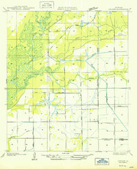
1950 Map of Hecker
USGS Topo · Published 1950About this map
The Calcasieu River meanders through the western reaches of this landscape, its path defined by numerous switchbacks and offshoots like Stackpole Bayou. Settlement is concentrated at Hecker, while the surrounding terrain in this part of Calcasieu Parish is characterized by a transition from wooded river bottoms to an organized system of water management. An Old Logging Railroad Grade cuts across the northern sections, tracing a path from the river through what was once productive timberland.
Find a feature on this map
20 named features on this map. Tap any name to fly to it.
Don’t see what you’re looking for? This feature index may not catch every label — zoom into the map to look around manually.
Map Details
Editions of this 1950 Hecker Map
This is the sole edition of this map. No revisions or reprints were ever made.
Other maps of this area

1932 · Lake Charles NE
USGS Topo · 1:31,680

1932 · Lake Charles NW
USGS Topo · 1:31,680

1935 · Moss Bluff
USGS Topo · 1:31,680

1935 · Gaytine
USGS Topo · 1:31,680

1942 · Lake Charles
USGS Topo · 1:62,500

1946 · Lacassine
USGS Topo · 1:31,680

1947 · Gaytine
USGS Topo · 1:31,680

1947 · Fenton
USGS Topo · 1:31,680

1947 · Moss Bluff
USGS Topo · 1:31,680

1947 · Hecker
USGS Topo · 1:31,680