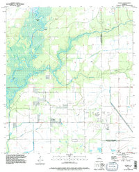
1994 Map of Hecker
USGS Topo · Published 1996About this map
The Calcasieu River meanders through the wetlands of southwestern Louisiana, defining a landscape of bayous and complex drainage patterns between Hecker and Le Bleu. This mid-1990s revision reveals a region where traditional riverine life meets industrial development, particularly within the Iowa Oil and Gas Field in the southern portion of the quadrangle. Significant water features like Stackpole Island and Bayou Serpent illustrate the low-lying terrain, while the Louisiana Irrigation Canal and various sludge pits mark the human modification of the parish line area. Genealogists may find interest in the proximity of family-named landmarks such as Hebert Cem and La France Cem, which persist alongside the shifting waterways and agricultural infrastructure of Calcasieu and Jefferson Davis Parishes.
Find a feature on this map
16 named features on this map. Tap any name to fly to it.
Don’t see what you’re looking for? This feature index may not catch every label — zoom into the map to look around manually.
Map Details
Editions of this 1994 Hecker Map
This is the sole edition of this map. No revisions or reprints were ever made.
Other maps of this area

1932 · Lake Charles NE
USGS Topo · 1:31,680

1932 · Lake Charles NW
USGS Topo · 1:31,680

1935 · Moss Bluff
USGS Topo · 1:31,680

1935 · Gaytine
USGS Topo · 1:31,680

1942 · Lake Charles
USGS Topo · 1:62,500

1946 · Lacassine
USGS Topo · 1:31,680

1947 · Gaytine
USGS Topo · 1:31,680

1947 · Fenton
USGS Topo · 1:31,680

1947 · Moss Bluff
USGS Topo · 1:31,680

1947 · Hecker
USGS Topo · 1:31,680