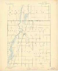
1894 Map of Hecla
USGS Topo · Published 1894About this map
The North Dakota South Dakota Boundary Line divides this late nineteenth-century prairie landscape, where the meandering James River carves a broad, marshy path through the James River Valley. The early settlement of the region is anchored by the Chicago and North-Western Railway, which runs a straight line through the center of the sheet. Under the direction of J.W. Powell, surveyors captured the transition from open prairie to structured township grids, such as Lansing, Liberty, and Portage.
Find a feature on this map
16 named features on this map. Tap any name to fly to it.
Don’t see what you’re looking for? This feature index may not catch every label — zoom into the map to look around manually.
Map Details
Editions of this 1894 Hecla Map
4 editions found
Other maps of this area

1894 · Hecla
USGS Topo · 1:62,500

1894 · Columbia
USGS Topo · 1:62,500

1894 · Savo
USGS Topo · 1:62,500

1894 · Fullerton
USGS Topo · 1:62,500

1894 · Oakes
USGS Topo · 1:62,500

1895 · Lamoure
USGS Topo · 1:125,000

1896 · Columbia
USGS Topo · 1:125,000

1918 · La Moure
USGS Topo · 1:125,000

1952 · Columbia NE
USGS Topo · 1:24,000

1953 · Jamestown
USGS Topo · 1:250,000