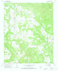
1962 Map of Hector
USGS Topo · Published 1973About this map
Hector serves as the focal point for this early 1960s survey of the Arkansas uplands, where the foothills meet the dense timber of the Ozark National Forest. The landscape is defined by the significant elevation of White Oak Mountain and Buck Mountain, punctuated by the Peterman Lookout Tower standing watch over the ridges. This period shows a rural community centered around small settlements like Appleton, Caglesville, and Buttermilk, with numerous country churches and cemeteries providing a map of local lineage. The drainage pattern is complex, with Illinois Bayou and Clear Creek carving deep valleys through the terrain. Evidence of rural industry and social infrastructure is visible in the scattered Walnut Grove Ch and Rehoboth Ch, while family burial sites like Tate Cem and Kinstow Cem offer valuable data for genealogical research into the region's mid-century inhabitants.
Find a feature on this map
40 named features on this map. Tap any name to fly to it.
Don’t see what you’re looking for? This feature index may not catch every label — zoom into the map to look around manually.
Map Details
Editions of this 1962 Hector Map
2 editions found
Other maps of this area

1879 · Washington
USGS Topo · 1:62,500

1887 · Smyrna
USGS Topo · 1:62,500

1888 · Dardanelle #1
USGS Topo · 1:62,500

1889 · Treat
USGS Topo · 1:62,500

1889 · Marshall #3
USGS Topo · 1:62,500

1890 · Dardanelle
USGS Topo · 1:125,000

1892 · Marshall
USGS Topo · 1:125,000

1892 · Morrillton
USGS Topo · 1:125,000

1894 · Morrillton
USGS Topo · 1:125,000

1894 · Marshall
USGS Topo · 1:125,000