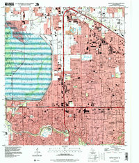
1995 Map of Hedwig Village
USGS Topo · Published 1999About this map
Buffalo Bayou and its winding tributaries, including Rummel Creek, Briar Branch, and Spring Branch, anchor this western Houston landscape during a period of significant suburban expansion. The map detail highlights a cluster of affluent residential villages including Hedwig Village, Bunker Hill Village, and Piney Point Village, which are defined by their wooded lots and proximity to the Lakeside Country Club. To the west, the massive scale of the Addicks Cullen Reservoir Park and Bear Creek Park provides a sharp contrast to the dense network of subdivisions and major commercial hubs like the Memorial City Shopping Center and the Town and Country Mall. Numerous educational facilities, from the Spring Branch Ed Center to Stratford High Sch, illustrate the mid-90s civic infrastructure, while Memorial Oaks Cem and several Oil Wells scattered near the Addicks Cullen Reservoir point to the region's diverse land use history.
Find a feature on this map
106 named features on this map. Tap any name to fly to it.
Don’t see what you’re looking for? This feature index may not catch every label — zoom into the map to look around manually.
Map Details
Editions of this 1995 Hedwig Village Map
This is the sole edition of this map. No revisions or reprints were ever made.
Other maps of this area

1915 · Bellaire
USGS Topo · 1:24,000

1915 · Houston Heights
USGS Topo · 1:24,000

1915 · Alief
USGS Topo · 1:24,000

1915 · Cypress
USGS Topo · 1:24,000

1915 · Addicks
USGS Topo · 1:24,000

1915 · Hillendahl
USGS Topo · 1:24,000

1915 · Clodine
USGS Topo · 1:24,000

1916 · Aldine
USGS Topo · 1:24,000

1916 · Satsuma
USGS Topo · 1:24,000

1918 · Cypress
USGS Topo · 1:31,680
Featured Places
- Houston, TX
- Jersey Village, TX
- Hunters Creek Village, TX
- Bunker Hill Village, TX
- Spring Valley Village, TX