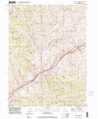
1997 Map of Heiners Creek
USGS Topo · Published 2001About this map
Echo Canyon Creek defines the lower corridor of this high-elevation terrain on the Summit County and Morgan County border. The landscape is characterized by a network of steep drainages, including the Hollow of the Thistles and Wolf Hollow, which feed into Heiners Creek. Human intervention in this environment is marked by an adqueduct following the canyon floor and a radio facility situated on a southern ridge. A web of 4wd tracks provides the primary access through the canyons, connecting scattered water sources like Mud Spring and the Left Fork. The presence of several borrow pits near the main canyon floor suggests local material extraction for the infrastructure lining the creek, while the higher elevations remain largely undeveloped with named features focusing on topographic landmarks and seasonal water.
Find a feature on this map
34 named features on this map. Tap any name to fly to it.
Don’t see what you’re looking for? This feature index may not catch every label — zoom into the map to look around manually.
Map Details
Editions of this 1997 Heiners Creek Map
This is the sole edition of this map. No revisions or reprints were ever made.
Other maps of this area

1885 · Salt Lake
USGS Topo · 1:250,000

1900 · Coalville
USGS Topo · 1:125,000

1903 · Coalville
USGS Topo · 1:125,000

1954 · Salt Lake City
USGS Topo · 1:250,000

1954 · Ogden
USGS Topo · 1:250,000

1958 · Ogden
USGS Topo · 1:250,000

1958 · Salt Lake City
USGS Topo · 1:250,000

1960 · Ogden
USGS Topo · 1:250,000

1960 · Salt Lake City
USGS Topo · 1:250,000

1964 · Lost Creek Dam
USGS Topo · 1:24,000