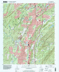
1997 Map of Helena
USGS Topo · Published 2001About this map
The Cababa River winds through a landscape defined by the parallel ridges of Shades Mountain and Oak Mountain as suburban growth expands from Hoover and Pelham. Industrial activity is evident at the Scottrock Quarry and a nearby Strip Mine, reflecting the region's long-standing reliance on local mineral resources. The map captures established communities like Helena and Alabaster, alongside smaller settlements such as Falliston and Hardy. Educational and spiritual centers serve the growing population, including the Indian Spring Sch, Mars Hill Ch, and Piney Grove Ch. Significant green space is preserved in the east at Oak Mountain State Park, while local history is maintained at the Pelham Cem and the Jefferson Garden of Memories.
Find a feature on this map
56 named features on this map. Tap any name to fly to it.
Don’t see what you’re looking for? This feature index may not catch every label — zoom into the map to look around manually.
Map Details
Editions of this 1997 Helena Map
This is the sole edition of this map. No revisions or reprints were ever made.
Other maps of this area

1890 · Bessemer
USGS Topo · 1:125,000

1892 · Bessemer
USGS Topo · 1:125,000

1905 · Bessemer Iron District
USGS Topo · 1:62,500

1906 · Vandiver
USGS Topo · 1:62,500

1907 · Bessemer Special
USGS Topo · 1:62,500

1908 · Vandiver
USGS Topo · 1:62,500

1909 · Columbiana
USGS Topo · 1:62,500

1910 · Montevallo
USGS Topo · 1:62,500

1911 · Columbiana
USGS Topo · 1:62,500

1953 · Birmingham
USGS Topo · 1:250,000