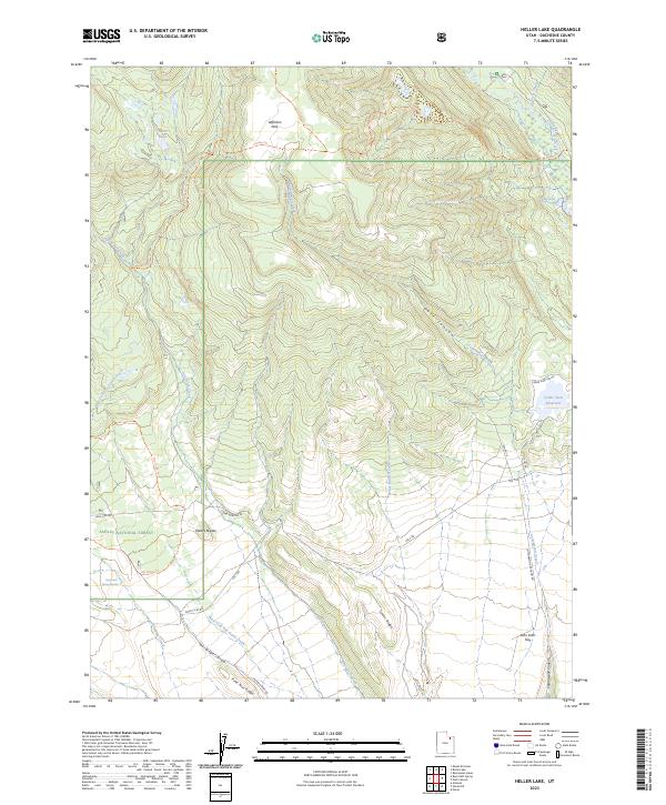
2023 Map of Heller Lake
USGS Topo · Published 2023About this map
Ashley National Forest dominates the high-elevation landscape of Duchesne County, Utah, where a complex network of seasonal drainages and named ridges define the terrain. The central hydrology is anchored by Heller Lake and the southward-flowing Cottonwood Creek, which carves through Dark Canyon toward the valley below. This modern survey illustrates the intersection of wilderness and management, showing how established trails like the Lowline Trl and Lily Pad Trl traverse the Jefferson Park area, while vital water resources like the Cedar View Reservoir and Big Spring support the arid ecosystem.
Find a feature on this map
30 named features on this map. Tap any name to fly to it.
Don’t see what you’re looking for? This feature index may not catch every label — zoom into the map to look around manually.
Map Details
Editions of this 2023 Heller Lake Map
This is the sole edition of this map. No revisions or reprints were ever made.
Other maps of this area

1885 · Uinta
USGS Topo · 1:250,000

1905 · Gilbert Peak
USGS Topo · 1:125,000

1906 · Gilbert Peak
USGS Topo · 1:125,000

1939 · Duchesne
USGS Topo · 1:125,000

1954 · Salt Lake City
USGS Topo · 1:250,000

1958 · Salt Lake City
USGS Topo · 1:250,000

1960 · Salt Lake City
USGS Topo · 1:250,000
1965 · Rasmussen Lakes
USGS Topo · 1:24,000
1965 · Neola
USGS Topo · 1:24,000
1965 · Pole Creek Cave
USGS Topo · 1:24,000