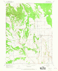
1965 Map of Neola
USGS Topo · Published 1967About this map
The settlement of Neola serves as a focal point on the eastern edge of this mid-1960s study, situated just south of the Uintah and Ouray Indian Reservation boundary. The landscape is defined by an intricate network of irrigation, including the Yellowstone Feeder Canal, the Uintah Canal, and various numbered laterals like Lateral No 1 and Lateral No 2. These systems were critical for supporting agriculture across the Neph Bench and the broad, terraced terrain of Coyote Basin. To the west, the topography shifts towards the elevated John Starr Flat and the deep incision of Cottonwood Canyon. Small-scale resource extraction is evidenced by scattered oil wells and a drill hole near the curve of The Crescent, reflecting the region's diverse land use between tribal lands and local ranching interests.
Find a feature on this map
32 named features on this map. Tap any name to fly to it.
Don’t see what you’re looking for? This feature index may not catch every label — zoom into the map to look around manually.
Map Details
Editions of this 1965 Neola Map
This is the sole edition of this map. No revisions or reprints were ever made.
Other maps of this area

1885 · Ashley
USGS Topo · 1:250,000

1885 · Uinta
USGS Topo · 1:250,000

1905 · Gilbert Peak
USGS Topo · 1:125,000

1906 · Gilbert Peak
USGS Topo · 1:125,000

1906 · Marsh Peak
USGS Topo · 1:125,000

1908 · Marsh Peak
USGS Topo · 1:125,000
1917 · Vernal
USGS Topo · 1:125,000
1939 · Duchesne
USGS Topo · 1:125,000

1954 · Salt Lake City
USGS Topo · 1:250,000

1954 · Vernal
USGS Topo · 1:250,000