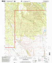
1996 Map of Heller Lake
USGS Topo · Published 1999About this map
The Uintah and Ouray Indian Reservation boundary defines much of the southern landscape here, where the high desert terrain transitions into the managed timberlands of the Ashley National Forest. This 1990s revision reveals a complex network of seasonal drainage and ridge systems, most notably Tower Ridge and the broad expanse of John Starr Flat. The presence of the Dry Gulch Guard Station (Indian) and the Big Spring Recreation Area indicates the dual importance of administrative oversight and public recreation within these federal and tribal lands.
Find a feature on this map
25 named features on this map. Tap any name to fly to it.
Don’t see what you’re looking for? This feature index may not catch every label — zoom into the map to look around manually.
Map Details
Editions of this 1996 Heller Lake Map
This is the sole edition of this map. No revisions or reprints were ever made.
Other maps of this area

1885 · Uinta
USGS Topo · 1:250,000

1905 · Gilbert Peak
USGS Topo · 1:125,000

1906 · Gilbert Peak
USGS Topo · 1:125,000

1939 · Duchesne
USGS Topo · 1:125,000

1954 · Salt Lake City
USGS Topo · 1:250,000

1958 · Salt Lake City
USGS Topo · 1:250,000

1960 · Salt Lake City
USGS Topo · 1:250,000
1965 · Rasmussen Lakes
USGS Topo · 1:24,000
1965 · Neola
USGS Topo · 1:24,000
1965 · Pole Creek Cave
USGS Topo · 1:24,000