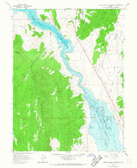
1965 Map of Hells Kitchen Canyon SW
USGS Topo · Published 1967About this map
The Sevier Bridge Reservoir dominates this central Utah landscape, showing the managed water levels of the Sevier River as they stood in the mid-1960s. The terrain transitions sharply from the alluvial floor of the reservoir to the high elevations of the Valley Mountains in the west and Cedar Ridge to the east. This survey records a landscape shaped by both natural drainage and human utility, with numerous canyons such as Maple Canyon, Timber Canyon, and Hells Kitchen Canyon cutting through the uplands.
Find a feature on this map
23 named features on this map. Tap any name to fly to it.
Don’t see what you’re looking for? This feature index may not catch every label — zoom into the map to look around manually.
Map Details
Editions of this 1965 Hells Kitchen Canyon SW Map
This is the sole edition of this map. No revisions or reprints were ever made.
Other maps of this area

1885 · Manti
USGS Topo · 1:250,000

1885 · Sevier Desert
USGS Topo · 1:250,000

1895 · Manti
USGS Topo · 1:250,000
1952 · Scipio North
USGS Topo · 1:62,500

1953 · Delta
USGS Topo · 1:250,000

1956 · Price
USGS Topo · 1:250,000

1958 · Delta
USGS Topo · 1:250,000

1960 · Price
USGS Topo · 1:250,000

1962 · Price
USGS Topo · 1:250,000

1962 · Delta
USGS Topo · 1:250,000