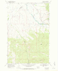
1968 Map of Helmville
USGS Topo · Published 1971About this map
Helmville sits at the northern edge of this Powell County landscape, serving as a focal point for ranching and water management in the late 1960s. The local geography is defined by an intricate system of irrigation, notably the Helmville Canal and the Douglas Creek Canal, which divert water from Nevada Creek to support the valley bottom. To the south, the terrain rises toward the foothills and peaks of the Helena National Forest, culminating at Hoodoo Mountain. This area reveals the extractive history of the region through the Roselle Mine and other unnamed mines tucked into Puzzle Gulch and the surrounding heights. Evidence of local infrastructure and community life is visible at the Cem just north of town and the various gulches, such as Chimney Gulch and Pole Gulch, that cut through the undulating landscape.
Find a feature on this map
23 named features on this map. Tap any name to fly to it.
Don’t see what you’re looking for? This feature index may not catch every label — zoom into the map to look around manually.
Map Details
Editions of this 1968 Helmville Map
2 editions found
Other maps of this area

1889 · Helena
USGS Topo · 1:250,000

1893 · Helena
USGS Topo · 1:250,000

1899 · Helena
USGS Topo · 1:250,000

1903 · Helena
USGS Topo · 1:250,000

1919 · Drummond
USGS Topo · 1:125,000

1921 · Drummond
USGS Topo · 1:125,000

1947 · Butte
USGS Topo · 1:250,000

1958 · Butte
USGS Topo · 1:250,000

1958 · Drummond
USGS Topo · 1:62,500

1958 · Garrison
USGS Topo · 1:62,500