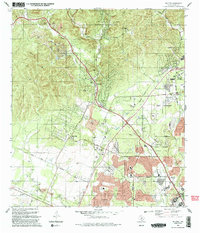
1992 Map of Helotes
USGS Topo · Published 1992About this map
Helotes and Grey Forest represent the expanding northwestern edge of Bexar County in the early 1990s, where the rugged Balcones Escarpment transitions into the suburban growth of San Antonio. The landscape is defined by a series of drainages including Helotes Creek, Los Reyes Creek, and Chimenea Creek that cut through the limestone terrain of Black Hill. This era captures the significant institutional footprint of the University of Texas at San Antonio and the Latin American Bible Institute alongside traditional rural elements. Local genealogy is well-documented through numerous family and community burial sites such as Menchaca Cem, Media Cem, Lee Cem, and Helotes Cem, which anchor the map's historical geography. Rapid development is evident in the expanding residential grids near Schnabel Park and along major thoroughfares like Braun Road and Hausman Road, contrasting with the more dispersed settlements to the west.
Find a feature on this map
39 named features on this map. Tap any name to fly to it.
Don’t see what you’re looking for? This feature index may not catch every label — zoom into the map to look around manually.
Map Details
Editions of this 1992 Helotes Map
2 editions found
Other maps of this area

1953 · Otis Ridge
USGS Topo · 1:24,000

1953 · Culebra Hill
USGS Topo · 1:24,000

1953 · San Antonio West
USGS Topo · 1:24,000

1953 · Helotes
USGS Topo · 1:24,000

1953 · Castle Hills
USGS Topo · 1:24,000

1953 · Van Raub
USGS Topo · 1:24,000

1954 · San Antonio
USGS Topo · 1:250,000

1956 · Medina Lake
USGS Topo · 1:62,500

1957 · San Antonio
USGS Topo · 1:250,000

1958 · La Coste NE
USGS Topo · 1:24,000