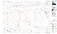
1985 Map of Hemingford
USGS Topo · Published 1986About this map
Agate Fossil Beds National Monument anchors the western portion of this High Plains landscape, where the Niobrara River carves a path through the Nebraska panhandle. Scientific interest is concentrated at the University of Nebraska Carnegie Hill, while the surrounding terrain is defined by the high tablelands of Dutch Flats and prominent landmarks like Mount Edna and the Chalk Buttes.
Find a feature on this map
44 named features on this map. Tap any name to fly to it.
Don’t see what you’re looking for? This feature index may not catch every label — zoom into the map to look around manually.
Map Details
Editions of this 1985 Hemingford Map
2 editions found
Other maps of this area

1896 · Patrick
USGS Topo · 1:125,000

1896 · Browns Creek
USGS Topo · 1:125,000

1898 · Scotts Bluff
USGS Topo · 1:125,000

1898 · Camp Clarke
USGS Topo · 1:125,000

1899 · Browns Creek
USGS Topo · 1:125,000

1899 · Goshen Hole
USGS Topo · 1:125,000

1899 · Whistle Creek
USGS Topo · 1:125,000

1946 · Nonpareil
USGS Topo · 1:24,000

1946 · Box Butte Reservoir West
USGS Topo · 1:24,000

1947 · Bronco Lake
USGS Topo · 1:24,000