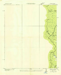
1935 Map of Hemp Top
USGS Topo · Published 1935About this map
Blue Ridge heights define the boundary between Polk and Fannin counties in this mid-1930s topographical study conducted by the Tennessee Valley Authority. The map details a landscape transition where narrow mountain gaps and ridges dictate the flow of movement and settlement. A Fire Tower sits atop Hemp Top, overlooking the vast National Forest and providing a strategic vantage point for fire lookout efforts during the era.
Find a feature on this map
25 named features on this map. Tap any name to fly to it.
Don’t see what you’re looking for? This feature index may not catch every label — zoom into the map to look around manually.
Map Details
Editions of this 1935 Hemp Top Map
This is the sole edition of this map. No revisions or reprints were ever made.
Other maps of this area

1886 · Dalton
USGS Topo · 1:125,000

1886 · Cleveland
USGS Topo · 1:125,000

1888 · Ellijay
USGS Topo · 1:125,000

1892 · Cleveland
USGS Topo · 1:125,000

1892 · Ellijay
USGS Topo · 1:125,000

1892 · Dalton
USGS Topo · 1:125,000

1893 · Murphy
USGS Topo · 1:125,000

1895 · Cleveland
USGS Topo · 1:125,000

1897 · Dalton
USGS Topo · 1:125,000

1898 · Ellijay
USGS Topo · 1:125,000