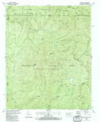
1988 Map of Hemp Top
USGS Topo · Published 1988About this map
Bethlehem Ch stands as a solitary landmark within the protected mountain corridor where the Cherokee National Forest and Chattahoochee National Forest meet. This late-twentieth-century survey reveals a landscape defined by its recovery and preservation, following the Georgia and Tennessee border across the peaks of Big Frog Mountain and Cowpen Mountain. The intricate drainage system of the Jacks River and the Conasauga River dominates the topography, carved by numerous tributaries like Panther Creek and Rough Creek.
Find a feature on this map
92 named features on this map. Tap any name to fly to it.
Don’t see what you’re looking for? This feature index may not catch every label — zoom into the map to look around manually.
Map Details
Editions of this 1988 Hemp Top Map
This is the sole edition of this map. No revisions or reprints were ever made.
Other maps of this area

1886 · Dalton
USGS Topo · 1:125,000

1886 · Cleveland
USGS Topo · 1:125,000

1888 · Ellijay
USGS Topo · 1:125,000

1892 · Cleveland
USGS Topo · 1:125,000

1892 · Ellijay
USGS Topo · 1:125,000

1892 · Dalton
USGS Topo · 1:125,000

1893 · Murphy
USGS Topo · 1:125,000

1895 · Cleveland
USGS Topo · 1:125,000

1897 · Dalton
USGS Topo · 1:125,000

1898 · Ellijay
USGS Topo · 1:125,000