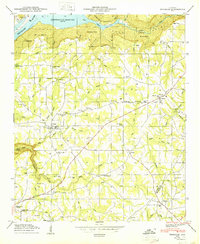
1950 Map of Henagar
USGS Topo · Published 1950About this map
Sand Mountain dominates this portion of the Cumberland Plateau in Northeast Alabama, where the transition from high-elevation farmland to the river valley is marked by deep hollows and gaps. Along the northern edge, the Tennessee River fills the Guntersville Reservoir, creating a sharp contrast between the aquatic boundary and the plateau's rugged rim. Local life in the mid-20th century is detailed through a network of rural crossroads like Pisgah and Rosalie, alongside numerous country churches including New Home Church and Mt Pisgah Ch. The landscape is etched with local history, from the Morris Mill on Jacobs Creek to family-linked landmarks like Clark Cem and Wininger Hollow. Higher up, unique natural features such as Saltpetre Cave and Split Rock Point overlook the Coon Creek drainage, illustrating the complex geography that shaped early Jackson and DeKalb County settlements.
Find a feature on this map
55 named features on this map. Tap any name to fly to it.
Don’t see what you’re looking for? This feature index may not catch every label — zoom into the map to look around manually.
Map Details
Editions of this 1950 Henagar Map
This is the sole edition of this map. No revisions or reprints were ever made.
Other maps of this area

1886 · Stevenson
USGS Topo · 1:125,000

1892 · Stevenson
USGS Topo · 1:125,000

1895 · Stevenson
USGS Topo · 1:125,000

1936 · Ider
USGS Topo · 1:24,000

1936 · Wannville
USGS Topo · 1:24,000

1936 · Flat Rock
USGS Topo · 1:24,000

1936 · Dugout Valley
USGS Topo · 1:24,000

1936 · Dutton
USGS Topo · 1:24,000

1936 · Sylvania
USGS Topo · 1:24,000

1936 · Hollywood
USGS Topo · 1:24,000