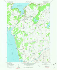
1959 Map of Henderson
USGS Topo · Published 1961About this map
Henderson Bay and the shoreline of Lake Ontario define the landscape of this 1959 survey, where the maritime character of Jefferson County meets a rural interior of family-named corners and small cemeteries. The settlement of Henderson Harbor serves as a focal point along the coast, while the village of Henderson sits slightly inland near Henderson Pond. Further south, the town of Ellisburg contains the hamlets of Rural Hill and Woodville, the latter situated near the winding course of Sandy Creek.
Find a feature on this map
72 named features on this map. Tap any name to fly to it.
Don’t see what you’re looking for? This feature index may not catch every label — zoom into the map to look around manually.
Map Details
Editions of this 1959 Henderson Map
Other maps of this area

1893 · Sackets Harbor
USGS Topo · 1:62,500

1895 · Sacketts Harbor
USGS Topo · 1:62,500

1895 · Stony Island
USGS Topo · 1:62,500

1895 · Pulaski
USGS Topo · 1:62,500

1942 · Stony Point
USGS Topo · 1:31,680

1942 · Henderson Bay
USGS Topo · 1:31,680

1942 · Point Peninsula
USGS Topo · 1:31,680

1942 · Sandy Creek
USGS Topo · 1:24,000

1943 · Henderson
USGS Topo · 1:31,680
1943 · Sackets Harbor
USGS Topo · 1:31,680