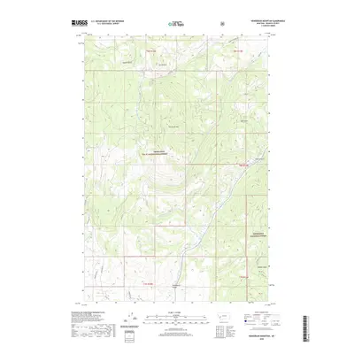
2020 Map of Henderson Mountain
USGS Topo · Published 2020About this map
Deerlodge National Forest dominates this mountain landscape in Granite County, where steep drainages and high summits define the local geography. The central heights of Henderson Mtn and Sunrise Mtn provide a dramatic backdrop to the winding Flint Creek valley. To the south, the terrain levels into the Phillipsburg Valley, a key topographical feature for local settlement and transit. The map documents a complex network of forest and county roads, including Black Pine Rd and Henderson Creek Rd, which provide access to the various gulches that carve into the range. Named features like Gaylord Gulch, Pickett Gulch, and Wyman Gulch suggest a history of prospecting or timber activity, common throughout this region of Montana. Waterways such as Smart Cr and Sawmill Cr thread through the forest, marking the primary drainage patterns for the surrounding peaks.
Find a feature on this map
29 named features on this map. Tap any name to fly to it.
Don’t see what you’re looking for? This feature index may not catch every label — zoom into the map to look around manually.
Map Details
Editions of this 2020 Henderson Mountain Map
This is the sole edition of this map. No revisions or reprints were ever made.
Other maps of this area

1908 · Philipsburg
USGS Topo · 1:125,000

1919 · Drummond
USGS Topo · 1:125,000

1921 · Drummond
USGS Topo · 1:125,000

1947 · Butte
USGS Topo · 1:250,000

1958 · Butte
USGS Topo · 1:250,000

1958 · Drummond
USGS Topo · 1:62,500

1959 · Bearmouth
USGS Topo · 1:62,500

1960 · Butte
USGS Topo · 1:250,000

1962 · Butte
USGS Topo · 1:250,000

1971 · Henderson Mountain
USGS Topo · 1:24,000