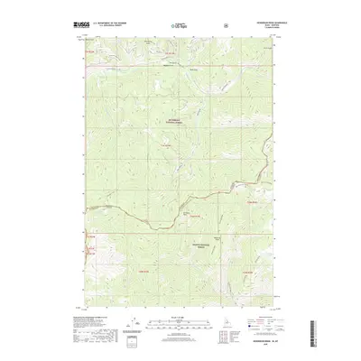
2020 Map of Henderson Ridge
USGS Topo · Published 2020About this map
Bitterroot National Forest and Salmon National Forest meet along the high, undulating border of Idaho and Montana. This 2020 survey documents the complex watershed where Hughes Creek and its many tributaries, such as Chrandall Creek and Spruce Creek, carve deep drainages through the steep landscape. The map provides a precise look at the forest service infrastructure, including Hughes Creek Rd and the Two Eagle Trl, which navigate the remote ridges. Notable landmarks like Irishmans Rock and the sharp profile of Butcher Knife Ridge stand out against the high-altitude terrain. Local hydrology is detailed through named features such as Muleshoe Springs and the interestingly named Bare And Tincan Springs, reflecting the era's continued reliance on identified water sources for navigation and management within these protected federal lands.
Find a feature on this map
46 named features on this map. Tap any name to fly to it.
Don’t see what you’re looking for? This feature index may not catch every label — zoom into the map to look around manually.
Map Details
Editions of this 2020 Henderson Ridge Map
This is the sole edition of this map. No revisions or reprints were ever made.
Other maps of this area

1956 · Elk City
USGS Topo · 1:250,000

1960 · Elk City
USGS Topo · 1:250,000

1960 · Painted Rocks Lake
USGS Topo · 1:62,500

1960 · Ulysses Mtn
USGS Topo · 1:62,500

1960 · Shoup
USGS Topo · 1:62,500

1960 · Piquett Mountain
USGS Topo · 1:62,500

1982 · Bighorn Crags
USGS Topo · 1:100,000
1991 · Piquett Mountain
USGS Topo · 1:24,000
1991 · Henderson Ridge
USGS Topo · 1:24,000
1991 · Ulysses Mountain
USGS Topo · 1:24,000