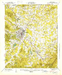
1947 Map of Hendersonville
USGS Topo · Published 1947About this map
Hendersonville serves as the central hub of this 1940s landscape, where the Southern Railway and the Dixie Highway intersect to define the region's transport corridor. The map illustrates a developed plateau surrounding the town, marked by resort-era features like Osceola Lake and Highland Lake, alongside organized recreational sites such as Camp Carlyle and Camp Pisgah. To the east, the terrain rises toward the Blue Ridge escarpment, while the southern reaches reveal the industrial and community footprints of East Flat Rock and Flat Rock.
Find a feature on this map
84 named features on this map. Tap any name to fly to it.
Don’t see what you’re looking for? This feature index may not catch every label — zoom into the map to look around manually.
Map Details
Editions of this 1947 Hendersonville Map
2 editions found
Other maps of this area

1905 · Pisgah
USGS Topo · 1:125,000

1906 · Pisgah
USGS Topo · 1:125,000

1907 · Saluda
USGS Topo · 1:125,000

1935 · Standingstone Mtn.
USGS Topo · 1:24,000

1935 · Horse Shoe
USGS Topo · 1:24,000

1935 · Batcave
USGS Topo · 1:24,000

1935 · Hendersonville
USGS Topo · 1:24,000

1935 · Fishtop
USGS Topo · 1:24,000

1935 · Zirconia
USGS Topo · 1:24,000

1936 · Skyland
USGS Topo · 1:24,000