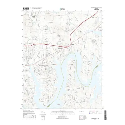
2016 Map of Hendersonville
USGS Topo · Published 2016About this map
Hendersonville and its surrounding residential corridors anchor this 2016 survey, which documents the suburban expansion along the northern banks of the Cumberland River. The landscape is defined by the sharp meanders of the river at Lindsley Bend and Cages Bend, where numerous inlets like Langford Cove have been developed into water-oriented communities. The transition from established neighborhoods to more rural terrain is evident as one moves north toward Shackle Island and Peytona. Several local landmarks provide historical continuity amidst the growth, including Ft Hill and traditional burial grounds like Woodlawn Cem and Stark Knob Cem. Significant infrastructure such as the Nashville Pike and the crossing of Station Camp Creek show the modern transportation network that facilitates access to these riverside settlements. Minor waterways including Drakes Creek and Hays Br continue to carve the topography, while prominent heights like Pilot Knob offer views over the valley.
Find a feature on this map
27 named features on this map. Tap any name to fly to it.
Don’t see what you’re looking for? This feature index may not catch every label — zoom into the map to look around manually.
Map Details
Editions of this 2016 Hendersonville Map
This is the sole edition of this map. No revisions or reprints were ever made.
Other maps of this area

1903 · Nashville
USGS Topo · 1:125,000

1932 · Hermitage
USGS Topo · 1:62,500

1942 · Gallatin
USGS Topo · 1:100,000

1942 · Lebanon
USGS Topo · 1:100,000

1951 · Martha
USGS Topo · 1:24,000

1952 · Goodlettsville
USGS Topo · 1:24,000

1952 · Hendersonville
USGS Topo · 1:24,000

1952 · Hermitage
USGS Topo · 1:24,000

1952 · Nashville East
USGS Topo · 1:24,000

1953 · Cottontown
USGS Topo · 1:24,000